Page 1 of 2
Elevation/Altitude Graphs are now available
Posted: Thu Oct 13, 2011 8:37 pm
by admin
Elevation/Altitude graphs are available for the first time on the Map Pedometer "My Routes" page:
http://www.mappedometer.com/routes/myroutes.php
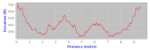
Now you don't have to wonder whether you will encounter any large hills on your running, walking, cycling, or hiking route. The elevation graph gives you a clear indication of where the hills are and the total elevation increase or elevation decrease along your route.
The Elevation/Altitude graph displays the elevation in feet or meters for your selected route. The units in the Elevation/Altitude graph can be changed by selecting "Miles" or "Kilometers" in the heading column of the route table. The Elevation Graph will update dynamically whenever you select a route from the route table.
To use the elevation graph feature, be sure that you are logged in before saving your Map Pedometer route. Elevation graphs are currently only available for Map Pedometer routes which were saved while you are logged in.
If you are not a registered user, you can become a Map Pedometer registered user for free. To log in or to register for a free Map Pedometer account, visit the Map Pedometer Log in/Registration page:
http://www.mappedometer.com/forum/ucp.php?mode=login
Please post your feedback here if you have any comments about the Elevation Graphs or encounter any issues.
UPDATE: 11/6/11 - Elevation graphs have been added to the Map Pedometer home page. Read the Nov 06 post below for details on the home page elevation graph.
Re: Elevation/Altitude Graphs are now available
Posted: Sun Oct 16, 2011 8:13 am
by secteur
Great addition of the elevation graphs. I've been using the site about a month (without being registered). I've mapped and saved many cycling routes. Climbing data was a poor approximation at best using the terrain lines. Wish I had seen this before yesterday ride. Had I know I was within 15 miles and maybe 500 vertical I could have completed my century ride. Thought I had another 1000 ft to go...
Re: Elevation/Altitude Graphs are now available
Posted: Fri Oct 21, 2011 2:15 pm
by admin
In response to a user request, we have added elevation statistics to the My Routes page.
Elevation statistics are listed above the elevation graph on the My Routes page. The elevation statistics include the elevation change, elevation increase, and elevation decrease of the selected route. The up elevation and down elevation statistics are calculated using a threshold mechanism which will ignore minor elevation changes. This algorithm helps provide a more accurate assessment of the actual up/down elevation changes encountered during a route. For example, a road that is virtually flat may repeatedly rise and fall by a few feet. Our up elevation and down elevation algorithm will ignore these minor elevation changes and only include elevation changes above a predefined threshold.
In addition, distance markers have been added to the route detail map on the My Routes page. You can use the route distance markers with the elevation graph to identify exactly where the hills are located along your route.
Re: Elevation/Altitude Graphs are now available
Posted: Sun Nov 06, 2011 3:12 pm
by admin
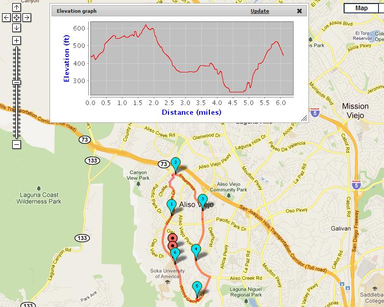
Elevation/Altitude graphs have been added to the Map Pedometer home page. You can now see elevation information while you are creating your route. Click on the "Elevation Graph" link at the top left of the map. A graph of the current route will be displayed. After changing the route, click on "Update" to update the graph. Click on the "X" to hide the graph.
Re: Elevation/Altitude Graphs are now available
Posted: Sat Dec 17, 2011 8:27 am
by lexybam
Wonderful addition of elevation graphs. I have been on this site for long and have not had any issue. Even when am not a registered member. Climbing data was poor an approximation at best using terrain. The point to note is the distance.
Re: Elevation/Altitude Graphs are now available
Posted: Sun Mar 04, 2012 4:22 pm
by RHarvey
Hi,
I am using this site to map some runs in Toronto, ON. I was referred here by a friend who will be running a marathon this summer and is using this site to help with planning her training.
I am unable to get the elevation data to display for my routes. For example, route 71751 is a route I know well and certainly has some elevation change that would be above the threshold, yet I don't see any elevation change displayed in the route information. Is this feature available for my area? Please let me know if you have any suggestions.
Thank you,
Ross
Re: Elevation/Altitude Graphs are now available
Posted: Mon Mar 05, 2012 8:11 am
by admin
The elevation information uses SRTM data. Apparently, the elevation information for the area in your route is not complete. I extended the route and there is elevation data available nearby. See route 71865 which was created based on your route 71751.
RHarvey wrote:Hi,
I am using this site to map some runs in Toronto, ON. I was referred here by a friend who will be running a marathon this summer and is using this site to help with planning her training.
I am unable to get the elevation data to display for my routes. For example, route 71751 is a route I know well and certainly has some elevation change that would be above the threshold, yet I don't see any elevation change displayed in the route information. Is this feature available for my area? Please let me know if you have any suggestions.
Thank you,
Ross
Re: Elevation/Altitude Graphs are now available
Posted: Thu Jul 26, 2012 4:41 am
by Ramboindahaus
Hi!
I've used the maps on this site for over an year and they have been really helpful to my training. The maps and the route marker works nicely even with the Finnish maps! Do you have any idea when I can get the elevation feature working in the maps of Finland?
Re: Elevation/Altitude Graphs are now available
Posted: Thu Jul 26, 2012 5:32 pm
by admin
Elevation data is available in Finland. Check out this route in Helsinki:
http://www.mappedometer.com/?maproute=110637
Occasionally, our elevation data provider does not have data for certain areas. Please send use a route number of a route which does not have elevation data. We will forward the information to our provider.
Thank you.
Ramboindahaus wrote:Hi!
I've used the maps on this site for over an year and they have been really helpful to my training. The maps and the route marker works nicely even with the Finnish maps! Do you have any idea when I can get the elevation feature working in the maps of Finland?
Re: Elevation/Altitude Graphs are now available
Posted: Thu Oct 25, 2012 2:32 pm
by romingTiger50
Well, the evelation graphs no longer work now. Help!!!